Contact Seller
Torr Antiques & Decorative Arts
Tel07931 370 372Please quote Antiques Atlas.


 Antique Framed Buckinghamshire Map, English, 17thC
 Antique Framed St Christopher & Nevis Map, English
 Antique Lincolnshire Map, English, Cartography
 Antique South America Map, English, Cartography
 Vintage Middlesex County Map, English, Framed
 Vintage County Map, Middlesex, English, Framed
 Vintage Western Australia Map, Framed Tallis Print
 Antique Road Map, London to Hythe, Kent, English
 Antique County Map, Cornwall, Kernow, English
 1889 Descriptive Map of London Poverty by C. Booth
 Original Camden/Norden Map of Middlesex & London
 Robert Morden Map of Wiltshire, c.1695
Non UK callers :
+44 7931 370 372
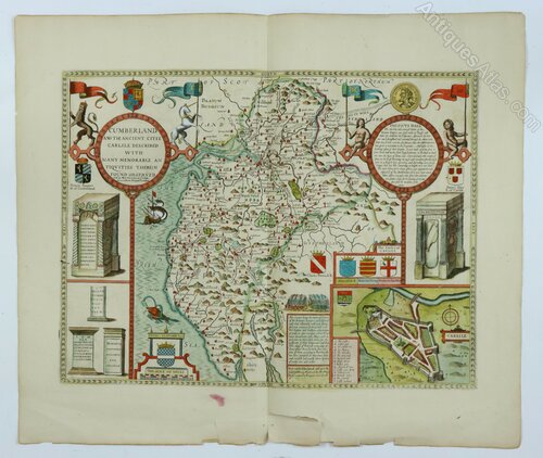
John Speed Map of Cumberland, Overton Ed c.1713


A hand-coloured original early 18th century map by John Speed titled: "CUMBERLAND AND THE ANCIENT CITIE CARLILE DESCRIBED WITH MANY MEMORABLE ANTIQUITIES THEREIN FOUND OBSERVED"
In a box to the left of the town plan of Carlisle it states: “Performed by John Speed and are to be sould by Henry Overton at the White Horse without Newgate, London”
This map, originally published in John Speed’s ‘Theatre of the Empire of Great Britaine’ between 1611 & 1676, is a later edition published by Henry Overton in ‘England Described’ from c.1713 to c.1756. The roads, following Ogilby's survey, were engraved onto the old plates for this edition. Plain on verso.
Dimensions: Paper - 52 x 61 cm Imprint (image) 38.5 x 54 cm
Condition: Very good and clean condition and with attractive hand-colouring. There are some marginal tears at the bottom of the sheet which do not affect the image however, these have now been repaired with PEL conservation tape.
Postage: £6 within the UK. The map will be rolled and posted in a cardboard tube.
SellerTorr Antiques & Decorative Arts
View all stock from
Torr Antiques & Decorative Arts

 Private dealer
By appointment only
Lamberhurst
Kent, England
Tel : 07931 370 372
Non UK callers : +44 7931 370 372
In a box to the left of the town plan of Carlisle it states: “Performed by John Speed and are to be sould by Henry Overton at the White Horse without Newgate, London”
This map, originally published in John Speed’s ‘Theatre of the Empire of Great Britaine’ between 1611 & 1676, is a later edition published by Henry Overton in ‘England Described’ from c.1713 to c.1756. The roads, following Ogilby's survey, were engraved onto the old plates for this edition. Plain on verso.
Dimensions: Paper - 52 x 61 cm Imprint (image) 38.5 x 54 cm
Condition: Very good and clean condition and with attractive hand-colouring. There are some marginal tears at the bottom of the sheet which do not affect the image however, these have now been repaired with PEL conservation tape.
Postage: £6 within the UK. The map will be rolled and posted in a cardboard tube.
Price The price has been listed in British Pounds.
Conversion rates as of 4/DEC/2025. Euro & Dollar prices will vary and should only be used as a guide.
Always confirm final price with dealer.
Category Antique Ephemera
Period Early 18th Century Antiques
Material Paper
Origin English
Maker John Speed
Item code as1016a806
Status Sold
£265.00 
$354.38 
€303.58 

$

€

Conversion rates as of 4/DEC/2025. Euro & Dollar prices will vary and should only be used as a guide.
Always confirm final price with dealer.
Shipping information
We have a trusted delivery man who is a experienced in transporting antiques, pictures and fragile items. He can deliver to most places on mainland England and Wales and, depending on where he is on his schedule, it may take a few days or up to 4 weeks. Other couriers are available for Scotland and North Wales or where a shorter time frame is required. Purchases can also be collected in person from the Tunbridge Wells area in SE England.
View all stock from
Torr Antiques & Decorative Arts

 Private dealer
By appointment only
Lamberhurst
Kent, England
Tel : 07931 370 372
Non UK callers : +44 7931 370 372
You may also be interested in
 Antique Framed Buckinghamshire Map, English, 17thC
 Antique Framed St Christopher & Nevis Map, English
 Antique Lincolnshire Map, English, Cartography
 Antique South America Map, English, Cartography
 Vintage Middlesex County Map, English, Framed
 Vintage County Map, Middlesex, English, Framed
 Vintage Western Australia Map, Framed Tallis Print
 Antique Road Map, London to Hythe, Kent, English
 Antique County Map, Cornwall, Kernow, English
 1889 Descriptive Map of London Poverty by C. Booth
 Original Camden/Norden Map of Middlesex & London
 Robert Morden Map of Wiltshire, c.1695

Websites for Antiques Dealers
Promote your stock and business
Read our testimonials
Read our testimonials